A must have for any hunter! Garmin’s Birdseye Satellite Imagery and their 24K Topo are an integral part of this Huntview Mapping as is BaseCamp which allows the user to interface their computer to their handheld to plan your hunt, transfer waypoints, and even keep a track log so you can return to the best hunting spots.
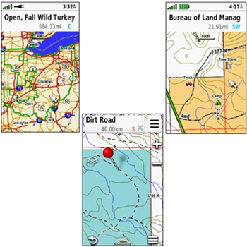
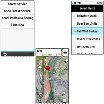
The HuntView Plus Topo maps gather their data from multiple sources not just USGS. Details are gathered from BLM, National Wildlife Refuges and Parks, WPA, and WMA. Trails and road data is turn by turn routable and public and private land types and boundaries are differentiated in colors.
- Plug and Play with Most Garmin Handheld Units – Alpha, Astro, eTrex 20/20x/30/30x/32x, eTrex Touch 25/35/35t, GPSMAP 62/64/65/66/67 Series, GPSMAP 276Cx, GPSMAP 78/78S/78SC/79/86, Garmin DriveTrack 70LMT, Montana Series, Oregon 600/700 Series, Overlander, Rino 650/650t/655t/750/755t, Tread Series
- Easy-to-use mapping solution for hunters and outdoorsmen – plug-in microSD card eliminates time-consuming downloads
- Identifies landowner names and boundaries for public/private land types and boundaries, using data from multiple sources for superior coverage and detail
- Includes Hunting Management Units containing boundaries and multiple species where available. *For reference only. Please always check Game land regulations to ensure accuracy.
- Digital topography equivalent to 1:24,000 scale U.S. Geological Survey maps
- Shows thousands of routable roads and trails with turn-by-turn navigation
- Includes searchable points of interest: parks, summits, geographic place names, camping areas, businesses, and more
- Provides Bureau of Land Management township, range and section information, plus USGS quad location
- Compatible with BaseCamp software for managing data on your GPS and computer, trip planning, playing back routes and tracks, geotagging photos and more
*Please note, your GPS may require software update for full compatibility.