Highly Detailed Charts for Your Navico Chartplotter!
The West Florida CMOR Card covers from Marco Island through St. Joseph Peninsula in high resolution. Previously called the 'Florida Middle Grounds Version 3', the West Florida chart includes some of the best fishing and diving areas in the Gulf of Mexico. The West Florida card includes data collected and processed in high resolution making it one of the best cards for detailed information. CMOR maps provide resolution as sharp as 1 meter in shallow areas while also providing extreme detail in deeper waters.
CMOR bathymetry is based exclusively on full-coverage surveys of the bottom with high-resolution echo sounding equipment. These maps are easy to read and interpret with depth being represented by color. Reds are the shallowest, purples and magentas the deepest. The West Florida CMOR chart also includes NOAA charts 11006 in the background.
South Florida Featured Areas include:
- St. Joseph Peninsula nearshore and deep drop coverage between Twin Ridges and Madison Swanson
- Big Bend exclusive data starting 25 miles offshore Alligator Harbor with spots from 5-11 fathoms
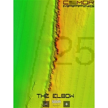
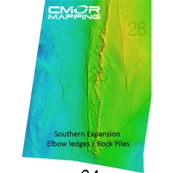
- Elbow covers over 50 square miles with depths ranging from 144-215'
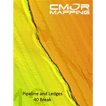
- The 40 break from Twin Ridges to Steam Boat lumps
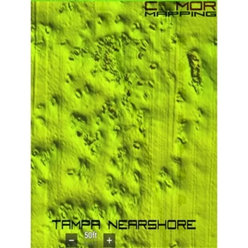
- Tampa includes bay channel and targeted wreck, structure and pipeline data from Pendola Point to 30 miles offshore
- Boca Grande Pass Includes 2.5 miles of Charlotte Harbor to over 4 miles offshore with depths from shoreline to 69' at the tarpon fishing hole
- Sanibel Island through Marco Island featuring some of the best fishing spots
- HDS Gen1 series
- HDS Gen2 series (both keypad and touchscreen)
- HDS Gen3 series
- HDS Carbon
- HDS Live
- Elite HDI series
- Elite CHIRP series
- Elite Ti series
- Elite FS series
- NSS
- NSS evo3
- NSS evo3S
- NSE
- NSO
- NSO evo2
- NSO evo3
- NSX
- GO XSE
- GO XSR
Whether you’re fishing for tarpon, snowy grouper, snapper or other bottom fish species, CMOR maps will help you locate fish hanging out in even the best hiding spots.
The CMOR chart for Navico is compatible with a wide range of Navico products including:
Lowrance
Simrad
CMOR Chart for West Florida for Navico Box Contents
Each CMOR Card for West Florida Comes with:
- CMOR Chart on MicroSD Card in SD Card Adaptor
CMOR Chart for West Florida for Navico Key Features
- Your vessel icon is overlaid on the CMOR data, showing you exactly where you are in relation to bottom features
- All vector data available on your plotter — tides, nav aids, routes, waypoints, etc.
- CMOR Mapping data is the result of methodical surveys with high-resolution echosounders
- Depth is represented by color. Reds are the shallowest, purples and magentas the deepest
- Your user data will still be accessible and will run on top of CMOR imagery