
Highly Detailed Charts for Your Navico Chartplotter!
The NE Florida, Georgia and South Carolina CMOR Card Coverage starts due east of Fernandina Beach in an area called R4 Navy Tower Bottom. Depths range from 100' to 2,200'. This section is 316 square miles and runs from the 30˚45.00' N line down to the 30˚36.00' N line. The southern section of this chart card starts east of Jacksonville on the 30˚29.00' N line and runs south to the 29˚53.00' N line, which is due east of St. Augustine. This section covers 941 square miles of data with depths ranging from 100' to 1,200'.
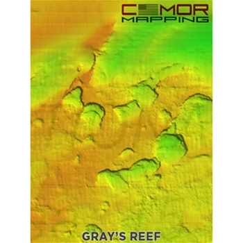
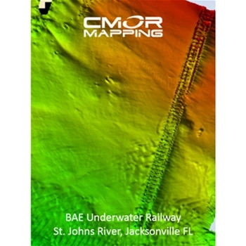
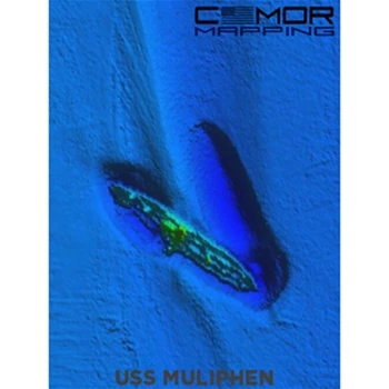
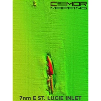
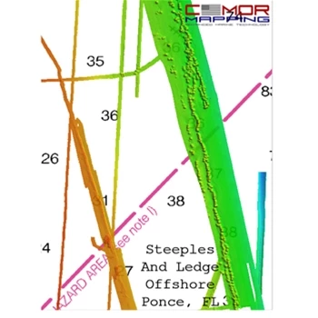
CMOR bathymetry is based exclusively on full-coverage surveys of the bottom with high-resolution echo sounding equipment. These maps are easy to read and interpret with depth being represented by color. Reds are the shallowest, purples and magentas the deepest. The NE Florida, Georgia and South Carolina CMOR chart also include NOAA charts in the background.
Featured Spots:
- 100 Fathom Curve (57nm ESE of Georgetown SC)
- Charleston Bump and many surrounding areas (swordfish mecca)
- Georgetown Hole (47nm SSE Georgetown SC)
- 100 / 400 area (59nm SE Little River Inlet, SC)
- Winyah Scarp (43nm SE Georgetown SC)
- “THE LEDGE” (47nm ESE Charleston SC)
- River Ledge 75ft depth (18.8nm SE Charleston SC)
- Charleston Natural Bottom 41-47ft depth (9nm SE Charleston Harbor)
- Charleston Shipping Channel
- Deep Drop / Swordfish Bottom 1331 to 1978ft 78nm SE Charleston SC
- Edisto Banks (50nm SE Edisto Island, SC)
- Southern Edisto Banks (8nm SW of Edisto Banks)
- The “DELI” (63nm SE of Hilton Head Island)
- Triple Ledge (66nm SE Savannah Georgia )
- Grays Reef Ledge 50-60ft depth (18nm SE Sapelo Sound GA)
- Natural Ledges Depths 60-65ft (18.5nm ESE St. Chatherines Sound)
- Anchor Ledge 75-82ft depth (26nm SE Ossabaw Sound)
- “GROUPER” ledges 120-128ft Depth (49nm East St. Simons)
- “KBY” Artificial Reef (9nm ENE Fernandina Beach, FL)
- SCAMP CITY 140-148ft depth (64nm East St. Mary's River)
- “FB” Natural Ledges (14nm ESE Fernandina Beach FL)
- Nassau Mud Humps (6nm E Nassau Sound)
- Jax Live Bottom 81-86ft deep (17nm E St. Johns River)
- Mayport Jetties and St. Johns River
- Pinnacles 1450 ft sand – 1351 ft top (43nm E Cape Canaveral)
Whether you’re fishing for swordfish, snowy grouper, snapper or simply enjoy diving beautiful reefs, CMOR maps will help you locate the best areas for your particular adventure.
The CMOR chart for Navico is compatible with a wide range of Navico products including:
Lowrance
- HDS Gen1 series
- HDS Gen2 series (both keypad and touchscreen)
- HDS Gen3 series
- HDS Carbon
- HDS Live
- Elite HDI series
- Elite CHIRP series
- Elite Ti series
- Elite FS series
Simrad
- NSS
- NSS evo3
- NSS evo3S
- NSE
- NSO
- NSO evo2
- NSO evo3
- GO XSE
- GO XSR
CMOR Chart for NE Florida, GA, SC for Navico Box Contents
Each CMOR Card for NE Florida, GA, SC for Navico Comes with:
- CMOR Chart on MicroSD Card in SD Card Adaptor
CMOR Chart for NE Florida, GA, SC for Navico Key Features
- Your vessel icon is overlaid on the CMOR data, showing you exactly where you are in relation to bottom features
- All vector data available on your plotter — tides, nav aids, routes, waypoints, etc.
- CMOR Mapping data is the result of methodical surveys with high-resolution echosounders
- Depth is represented by color. Reds are the shallowest, purples and magentas the deepest
- Your user data will still be accessible and will run on top of CMOR imagery