


Does Garmin Offer More Than GPS Products?
 The name Garmin has been synonymous with GPS products for a very long time, conjuring up images of vehicle products of highway navigation and city streets. However, what many might not realize is that Garmin is more than just an attractive accessory for the on-the-go consumer. Garmin is actually a leading manufacturer of a variety of products designed for on-the-water use. Marine applications combine the power of GPS location with additional layers of electronic tracking, while sonar and other high-resolution scanning equipment renders images which represent locations of groups of fish, creating easy to read displays capable of precisely displaying a digital rendering of current depth between the hull of a sea vessel and the seabed.
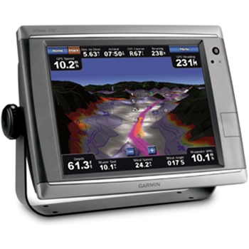
To understand the technology that comes into play in a marine environment we have to be aware of more than GPS. Global positioning is an essential awareness tool, but there's a whole lot more to worry about while sailing unknown waters than just position. The craft in question is floating above a hidden realm of hazards that's comprised of a fantastical landscape of submerged peaks and drops. That terrain affects the course of the vessel, influencing the dynamic manner in which underwater currents move. A Garmin Chartplotter, for example, charts underwater those contours on a dedicated set of maps, taking advantage of an aggregate of transducer technology to recreate the hidden realm. It combines this feature with radio and XM satellite information to pinpoint location and approaching weather conditions. Reserved radio bands are embedded in the device, with a sounder and transducer providing invaluable extra senses in mapping the undersea terrain with the aid of SONAR and cutting-edge computer graphics to generate a visual of the scanned hazards ahead.
The complexity of the equipment delivers a level of realism that feels a little like having access to an extra sense. Signal processing circuitry cleans images to leave a clear graphic of the world below. Transducers located above and below decks deliver an accuracy that's as basic as a digital compass bearing or as precise as a visual of every rock, school of fish, and location of submerged man-made structure. Audio and visual cues will sound out and flash to warn of approaching hazards, with Garmin's CHIRP technology showing higher resolution renderings of objects and sea life at greater depths than ever before. As with GPS systems used in automobiles, maps are included for these marine devices, but the maps describe charts of the contours of coastal areas and ocean beds.
Both the top-notch audio systems and chart scanners utilize the latest in touchscreen tech and wireless engineering, allowing navigators to chart a course with the touch of a fingertip and boat owners to install equipment without the clutter of wiring, an especially attractive benefit in the cramped environs of a boat. Additionally, audio considerations are taken care of by the capacity of sound systems being able to wirelessly stream high-quality music to any part of the vessel, dividing quarters into zones. Powerful enough to project sound in across the widest quarters of a yacht or the tiniest confines of a small sailing boat, Garmin audio systems add features specific to a marine setting. The system is typically designed to interface with other Garmin marine products, perhaps our Chartplotter example once more. Again, Bluetooth wireless adds increased functionality by reducing cables and adding a small remote that can access and control audio from a remote location. Note, if hooked up to a Chartplotter, the LCD on the display of the remote can be configured to relay information in digital shorthand, showing depth, water temperature, wind direction and more.
The GPS Store offers a range of Garmin GPS products ranging from aquatic navigation to wristwatches and just about everything in between.
